It was the last day of April when I pulled up in the car park in Newborough village. The month had already been officially named as the wettest April on record, even before the torrential downpour of the previous couple of days. March had come in like a lamb and left like a lion and things had only got worse since. Nonetheless the country was almost entirely officially “in drought” as a result of the lower than average rainfall in thirty three of the preceding thirty six months. Neither home nor Anglesey was yet subject to the hosepipe ban that the south and south-east had seen imposed in late March but there was no guarantee that this could be held off indefinitely. Of course, the rain had led to headlines about the “wettest drought on record” but water levels were undeniably low and the ground was firmer underfoot than would normally be the case this early in the year.
The main drought year in recent memory was of course 1976 and I well remember the cracked, parched ground, dried-up ponds and browned grass from our August holiday of that year. And it’s gone down in family lore that Martin had woken having heard a van’s loudspeaker advising that water would be cut-off during the morning (as it was elsewhere in the country, with standpipes much in evidence). As a result Gwen filled every saucepan in the kitchen, along with the bath upstairs, and their use was strictly rationed. It later became apparent that Martin had actually dreamed the loudspeaker and we needn’t have worried unduly, beyond taking the care and precautions that we had grown accustomed to over the course of the long, hot summer.
Unlike 1976, the morning in Newborough was by no means hot and by no means summer but it was dry and the forecast for the day was stable so rising early to drive the hundred and twenty miles was a risk worth taking. The Aberffraw to Newborough stage wasn’t the next if you were ticking the route off in order but I hadn’t done so to date and with the sheer volume of water that had fallen the day before I thought it best to avoid the cliff tops on this occasion.
Newborough village is far from attractive, being another example of the Welsh pebbledash vernacular architecture and I was glad to have timed things so well (or cut things so fine, delete as appropriate) that I had no more than two or three minutes to wait for the bus that would take me north on the A4080 to Aberffraw. The journey takes no more than eight minutes so it is a little galling to see that the return journey on foot is thirteen miles, albeit thirteen fairly flat miles. Strangely for a “coastal” path, there’s not a great deal of coast either - there are two estuaries cutting deep into the island’s interior that must be negotiated, along with the trees of Newborough Forest, before the final delayed gratification of Llanddwyn Island and beach.

Disembarking in Aberffraw it is hard to believe that this small village laid out around a little square was once the seat of the kings of the ancient Welsh nation of Gwynedd . Whilst there is no trace of the palace remaining (it was almost certainly wooden which made its destruction substantially easier) there is a modern Heritage Centre at the village’s edge. It was too early for this to be open though so I strode downhill to the attractive single-arch bridge over the river.
Many of the houses overlooking the estuary have lovely views but so few of them are attractive in themselves and I find it hard to understand why so few of the island’s buildings add to the undoubted beauty of the scenery. The bridge on the other hand is pretty and elegant and although it no longer carries the main road is still perfectly capable of carrying foot traffic across the River Ffraw, from which the village takes its name. Not bad for something built almost three hundred years ago in 1731 - the modern bridge that carries the road these days was first built in 1932 and has already been rebuilt on at least one occasion.

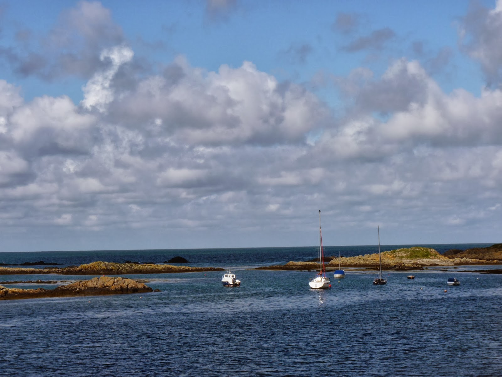
The estuary is tidal here and it was obvious that the tide was low from the number of boats lying high and dry on the far bank. This meant that I was able to saunter along the wet sand, feeling the differing textures beneath my boots - here it’s firm enough for a game of beach cricket; there it is slightly softer; and a few yards further - and closer to the water - you sink up to your ankles in a sudden quagmire. The water ran shallow and surprisingly clear - the ripples in the sand of the river bed could be easily made out - and a couple of oystercatchers were certainly enjoying its taste as they paddled in the margins. To the left of the sands were dunes and scrubland and marram grass but it was the view ahead that commanded the attention - a wide expanse of beach with an aquamarine sea beyond and the mountains of the Lleyn Peninsula away in the distance. The light seemed to have a luminosity to it that you don’t see inland and the sea appeared almost Mediterranean or Caribbean as a result. I didn’t put it to the test but I feel sure that its temperature would have been closer to the Arctic however, for there was a keen edge to the wind that sent little flurries skittering down the beach and ensured that sunglasses remained in place to keep your eyes clear.
As the beach opened out the path climbed left through the marram grass and turned inland across Aberffraw Common, and its mix of short grass cropped tight by sheep and rabbits with tall dunes and intervening hollows. Stunted hawthorn trees have been moulded by the wind to clearly illustrate its prevailing direction and ground-nesting birds take to the air to distract you from nests that you weren’t threatening in the first place. The song of skylarks was a clear sign that summer was coming, an impression confirmed when the first two swifts of the year came scything past, preceding the first flypast of the day courtesy of RAF Valley’s fighter pilots. It wasn’t spectacular scenery and the wildlife was nothing out of the ordinary but it was springtime and the sun was shining and I lingered long enough to enjoy it. This wasn’t a day for rushing it seemed to me.


At the edge of the common a signpost indicated the way ahead. A spider’s web hung from the fingerpost and as I watched its owner scuttled out to reel in a fly caught in its sticky embrace. I had never seen this in such close detail before and was fascinated by the way the fly was parcelled up and carried back to the spider’s larder in a knothole in the wooden sign. As I said, not a day for rushing - had I been in a hurry I would not have had the immense pleasure this little cameo moment gave to me, if not to the fly!
It is often these intimate little glimpses that are the most memorable on a walk and I was to enjoy another such moment having crossed two or three fields to a little farmhouse on the skyline. As the path turned left along a firm track I caught sight of a pied wagtail on the barbed wire fence ahead. I already had my camera handy and as quietly as I could raised it to my eye and took a shot. The bird didn’t seem to mind so I took a step closer and got off another shot; another step, another photo; and then another. I was amazed at how calm and unflustered the bird was but decided I was near enough - it seemed a pity to spook him when he had been good enough to let me approach so close. For a bird which has the most basic of palettes from which to work - black, white and grey - the pied wagtail is both beautiful and incredibly endearing, perhaps even more than their grey and yellow cousins. (Incidentally, the grey wagtail is largely yellow, which can cause confusion; the yellow wagtail is brighter still.)

I pushed on, glad that the cattle in the fields ahead seemed happy to ignore me - recently I had seemed to attract them to me like moths to a flame and although they are merely inquisitive rather than threatening, they can undoubtedly be intimidating given their sheer bulk. Jan finds them particularly stressful, to the extent that she hates being in the same field as cows, but strangely finds no comfort in my presence alongside her. It is true that there have been reports of them trampling ramblers - even fatally - over the last year or two but these remain very much the exception rather than the rule. Nonetheless, it makes sense to avoid confrontation wherever possible.
Beyond a slightly swollen stream and its muddy banks the path passes in front of the abandoned farmhouse of Bont-faen. The building itself is grey and ugly with health and safety notices warning of the dangers of climbing upon the fragile roof would not be worthy of comment but for the presence of a huge pile of what appear to be oyster shells to the left of the path. I would have passed by without having noticed them but for the noise made by a rabbit scrabbling up them, startled by my approach and seeking to escape what he could not have known were my entirely peaceful intentions. Once I had noticed, though, I was intrigued. They had obviously been dumped here - oysters are scarcely known for being creatures of scrubby farmland, nor are they drawn to mythical landlocked graveyards as elephants were once supposed to be - but the farm is a mile from any road (ideal for tipping perhaps) and where do you get this amount of shells from? There must be ten of thousands of them, maybe more, and you just don’t suddenly find that number that need tidying up. And how do you transport that many anyway? There’s a mystery here but I can find nothing on the internet to suggest an explanation - just photos to prove that I’m not imagining what I saw. The best answer that I can come up with is that they are from a seafood restaurant and dumped a few at a time but this hardly explains anything - in fact it makes it still more odd, for if they were dumped a few at a time, why could they not be disposed of in a more conventional manner. Very strange.
I had the chance to muse on things as the path headed across a number of grassy fields to the main A4080. The final field contained a small flock of sheep, five of whom were lying at the foot of the stile leading over the dry stone wall and onto the footpath. Loath though I was to disturb them, there was no other way of exiting the field and I apologised profusely as they dragged themselves to their feet and reluctantly vacated their comfy spot and moved away, however briefly. Across the road and down a quiet lane lay the church of St Cadwaladr, a burial ground for at least one King of Gwynnedd, Cadfan, who died in the early seventh century. I was particularly taken with the gargoyles in the stonework but also with the deep purple flowers of the honesty growing in the grassy verges on the approach to the church.

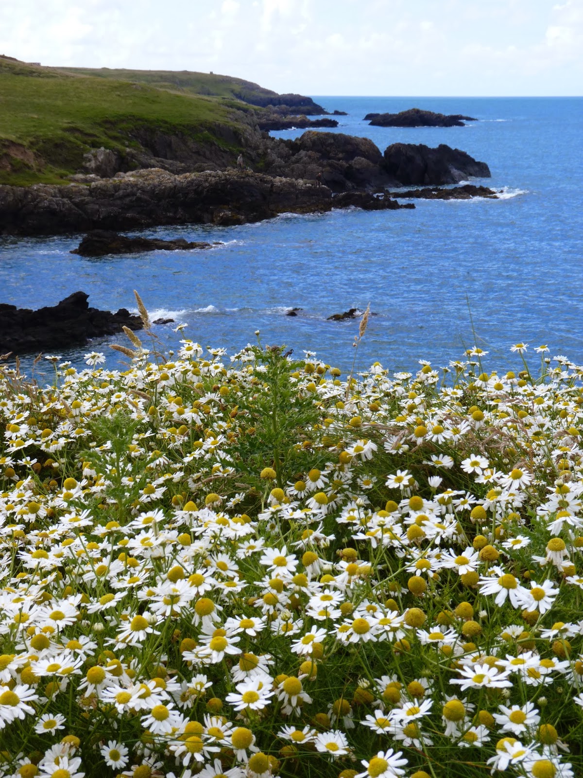
After a half mile of plodding alongside the A road - albeit a very quiet A road - a quiet side road led downhill and back towards the sea. Bluebells - pink, white and the traditional colour - lined the banks and butterflies were busy enjoying the nectar. Orange tips were especially prevalent and easily identifiable, having as they do an orange tip to their wings. Having read Patrick Barkham’s lovely book “The Butterfly Isles” the previous year, I was taking a greater interest in these beautiful creatures this spring and was ridiculously pleased to be able to identify even such an obvious species. A greater spotted woodpecker flew overhead, its “bouncing” flight making it one of the easier birds to identify in flight. Moments later I was to hear it drumming on a nearby tree - or at the very least, another woodpecker. It’s a sight I’d love to see but for the time being I’ve only seen them in flight or silhouetted stationary on a tree trunk, never “in action” as it were.
Lifting my head up to watch the woodpecker, my breath was taken away by the view across to the hills and mountains of Snowdonia. The highest summits still held a light covering of snow and I was taken aback by just how big they looked, and how close. Below me lay the Malltraeth Sands and the estuary of the Afon Cefni and I was greatly looking forward to seeing the sands and the variety of bird life that they support. Sadly, the path turns away left just before the estuary and takes a rather disappointing route through an area of marshland and scrub, the path overhung by small trees and hedging. It’s like being routed away to the tradesman’s entrance rather than enjoying the majestic views.
When the path finally does emerge onto the estuary it is a question of whether the views ahead or the properties to either side are the more impressive. These houses are far from the normal slate or pebbledashed cottages we have seen elsewhere in island villages; they are designed to make the most of the views across the sands to the mountains and the length of the gardens is in direct proportion to the width of the views. It’s not long before we again drop out of sight of the sands, tall dunes blocking any views away to the south and that marshy scrubland to the left. Here were butterflies and wildflowers to look at but they were no substitute for those wide-ranging vistas we’d left behind. Eventually the path reached the main street of the village beside the Royal Oak pub, turned right and made its way down to the river, the start of the sands and a little paved picnic area where I decided to take lunch.

Malltraeth is well regarded as one of the best bird watching sites on an island full of them and it was here that one of the best-known wildlife artists of the twentieth century came in 1947 to live and work. Charles Tunnicliffe and his wife Winifred had bought Shorelands, one of those spectacular properties overlooking the estuary seen earlier and moved here from their home in Cheshire. Charles had been born in the village of Langley, a few miles out of Macclesfield, in 1901 - the GPO tower above the village being visible from common at the end of my road. His family soon moved from their two-up-two-down terraced house to the tenancy farm of Sutton Lane Ends a mile or two distant, where his artistic talents began to be noticed. In 1916 he started at Macclesfield School of Art, moving on to the Royal College of Art in London where he met Winifred. After graduation they settled back in Macclesfield and he began teaching at Manchester Grammar School, supplementing his income with work as a commercial artist. Amongst his other work was providing illustrations for Tarka the Otter by Henry Williamson and he gradually became known for his wildlife paintings, drawings and woodblocks.
After moving to Shorelands following many years of visiting the island for holidays he continued to find work both as an illustrator and also as an author, including “A Shorelands Summer Diary” detailing the life and times of birds and other wildlife as viewed from his studio window. It is, though, his commercial work that my generation would recognise - his illustrations for Ladybird books and Brooke Bond picture cards. Brooke Bond had been putting picture cards in their packs of teabags since 1954 - one of their two examples of marketing genius from that decade; the other being the PG Tips chimps. The first album “The Frances Pitt Series of British Birds” was priced at 3d with twenty cards of a variety of species including such (modern) rarities as bittern, nightjar and turtle dove. So successful was the promotion that a second printing was required to meet demand. Later wildlife-based series included bird portraits. Wild flowers, African and Asian wildlife, tropical birds and wild birds in Britain, all illustrated by (and some “described by”) Charles Tunnicliffe. An internet search brings up many of the album covers of the series and brings on a rush of nostalgia at the sight of those albums I strove to fill as a young lad at primary school - “The Race For Space”, “Adventurers and Explorers” , “The Sea - Our Other World” and “Inventors and Inventions”.
Even before I had become aware of tea cards, though, I had known Ladybird books. First printed during the first world war, the books’ popularity increased enormously during and after the second world war when a standardised fifty-six page format was hit upon - the left hand page for words, the right for pictures and each of them with the ladybird logo on the front cover. Again Tunnicliffe was much in demand for his illustrative abilities, including a series on “What To See In …” for each of the four seasons. In hindsight, he may even be partially responsible for my fear of snakes as I vividly recall Nana and Grandad having to glue two pages of one of my books together to avoid my turning over and being frightened by a two-dimensional adder. Forty years later I am a little better but still find it hard to look at photos, although I think I can just about cope with drawings of them these days.

I suppose it is also possible that I have Tunnicliffe to thank for my love of non-reptilian wildlife. It is undoubtedly true that birds and animals have given me enormous pleasure over the years and that my spirits are easily raised on the worst of days at work if I should see a heron or buzzard whilst driving between appointments. And so it was that I was delighted within a few short minutes of striding out once more.
The Afon Cefni rises near the market town of Llangefni and is these days canalised for a large part of its journey to the sea. At Malltraeth it is released from this straitjacket and flows freely for its final couple of miles to the Irish Sea. In the past the river was tidal almost as far inland as Llangefni and the sands and mudflats extended significantly further than they do today. Since the canalisation the land has largely been reclaimed, a process aided by the building of “The Cob”, an embankment that was built during the 1800s as a flood defence. The path runs along the Cob with views out to the estuary on the right and the Cob Pool immediately to the left. This freshwater pond is one of three sizeable pools in the immediate vicinity and is a beacon for birdlife locally. A couple of seemingly wild ponies initially caught my eye but I was soon drawn to the far bank and a heron stalking a meal with great concentration and a slow high-stepping grace. Although I had only just started off again, I removed my rucksack to retrieve my binoculars and sat down for another ten minutes entertainment before a stab of the beak brought the hunt to a seemingly successful conclusion and what seemed like a largish frog that would no doubt have cost a pretty penny in a French restaurant.
Beyond the embankment the path plunges into Newborough Forest. The forest was largely planted during and immediately after the second world war, primarily to stabilise the shifting sand dunes. Over the years it has become home to one of the largest raven roosts in the country, if not the world, with about 2000 residents at one time, albeit now down to around 800. It has also been the site of a successful programme to reintroduce red squirrels to the area.

Sadly, neither squirrel nor raven were making their presence felt today but the long forest rides were perfect for the butterflies that had so enchanted me earlier. I took forever to walk a mile, stopping every few yards to try and get a decent photo of small white, peacock, orange tip and speckled wood. By the standards of those I’ve seen on the internet, I didn’t come close but I was ridiculously pleased with my efforts - eventually. I came fairly late to digital photography but now that I am a convert I see so much time disappear in the search of a half-decent photograph of whatever might attract my attention. Sarah rolls her eyes at me the moment I take my camera out on a walk as she knows she will be hanging around waiting for me to catch up, distracted as I will have been by flora, fauna or landscape. I will still be distracted without a camera but the need to record the distraction will, I fear, over-ride my sense of time.
Navigation through the forest was now dictated by the numbered posts at each junction - of which there were many. At junction number 17 I had to turn right to the edge of the woods and the estuarine salt marshes. I was reminded of the story Pat has often told of the day we visited Newborough. We’d picked up a nature trail leaflet of the kind that tells you to look out for a crossbill at point seven - because one had been seen there once a couple of years earlier. Anyway, Mum as the schoolteacher was given responsibility for reading the information out as we reached the appropriate numbered stakes. We all dutifully lined up to hear her describe the formation of the dune system, the geology of the volcanic rocks, the orchids and helleborines and so on. As we listened intently at one particular point it dawned upon us that her audience had grown somewhat - another family had attached itself to our own and were paying at least as much attention to her “lecture” as the Lee-Whelan clan. As we moved away to the next post the father politely approached her. “Would it be all right if we joined in the tour?” he asked, clearly under the impression that this was an “official” guided tour and that Mum knew what she was talking about. Somehow she managed to dissuade him from this opinion but thirty five years later it is still a favourite tale at family gatherings.

Back in the present day I managed to locate the correct path and was glad to emerge from the conifers and to find a delightful path running between forest to my left and salt marsh to my right. Another heron stood stock still at the edge of the reedbed but on this occasion too far away for me to get even a half-decent photo. Instead I found my attention drawn to the thrift at my feet. It’s a lovely little flower but I love the different names it has acquired over the years - sea pink is the most obvious but it is also known as rock rose, our ladies cushion, and Mary’s pillow. Anyway in this instance I think I got a decent shot or two and moved cheerfully on, a spring in my step despite the mileage already in my legs.

Unfortunately I made a small navigational error here and took the path that led back into the forest rather than crossing the dunes to the beach. Obviously I soon realised the error of my ways (it isn’t hard to tell the difference between sand and trees) but a glance at the map told me I could push on and still come out onto the beach alongside Llanddwyn Island. After twenty minutes of walking what seemed to be the same two hundred yards over and over again I was starting to regret that decision. The scenery was totally unchanging - at one point I took a photo of the path ahead, then turned to take one of the path already taken; it was impossible to tell them apart. I was hot and a little footsore; there was nothing to see other than conifers; there was little in the way of birdsong; and if truth be told, it was a little boring. Another twenty minutes went by. No change. Ten more passed and a path appeared leading away westwards. Within yards came the sight of pine trees, with a shining, shimmering sea and - so close, it seems, that you could touch them - the mountains of the Lleyn Peninsula beyond. It was such a beautiful sight and seemed all the better for the deferred gratification of the previous three quarters of an hour wishing I had taken the other path. I almost ran down to the beach and was delighted to see the anticipated island no more than two hundred yards away across the golden sands.

Llanddwyn Island is undoubtedly one of the highlights of the path. How we had never visited it before, I have no idea. Only at high tides does it become a true island but the fact remains that it is an island that you can walk to and be stranded upon and as such a tremendously romantic idea. I hurried across the sands and eagerly scrambled up the sandy path that led between marram grass up onto the island itself. A path side interpretation board tells the story of how the island got its name. Back in the mists of time Dwynwen, daughter of the King of Wales, was rejected by a suitor names Maelor at which time the Gods got involved and produced a potion with which Dwynwen turned Maelor to ice. Devastated at the turn events had taken, she then retired to the island and lived the rest of her life as a hermit. After her death she was sanctified and is now the Welsh equivalent of Saint Valentine. Llanddwyn means “the church of Saint Dwynwen” - the ruins of which can still be visited.
A decent path makes its way along the north-western side of the island, climbing up above the rocky shore to reach a large cross at what is close to its highest point. The view ahead is of the old lighthouse, modelled on the design of most Anglesey windmills (without the sails of course). This lighthouse replaced the original version in 1845 but has recently ceded responsibility back to the slightly older version - albeit with a much more recent light added to the top of the older building. The larger windmill style is an infinitely more attractive property, whitewashed and standing proudly on its promontory at the very tip of the island.
The way back to the beach passes by the Pilots’ Cottages, a row of single-storey cottages that contains an exhibition area, a cottage laid out as it would have been at the turn of the nineteenth and twentieth centuries and the accommodation for the wardens who spend their summers here. In years past they were occupied by the pilots who guided ships into and out of the Menai Straits on their way to and from Caernarfon harbour to collect and deliver slate from the mines in and around Llanberis. As we have seen all around the island, these are dangerous waters and so the job of pilot was an important one - important enough to be supported by a lifeboat that was based here up until 1907. A cannon that was used to summon its crew is to be found in front of the cottages and made for a decent photo with the whitewashed cottages behind.
Next on the path is a large Celtic cross, again on a rocky outcrop, dedicated to the memory of St Dwynwen. A few yards further on are the ruins of her former church, little more than a couple of walls these days and with grass close-grazed by the resident island ponies. These are kept on the island to assist in the management of the land for the resident wildlife - by keeping the turf close-cropped it allows wild flowers to flourish and also benefits ground nesting birds such as lapwing. This is appropriate as Llanddwyn was site of the first RSPB action in Wales, an attempt to safeguard a roseate tern colony threatened by egg thieves. Sadly, they are no longer here in any real numbers but at least the effort was made and cormorants, ringed plovers and grasshopper warblers thrive instead.
Of more immediate interest were the mountains clearly visible on the mainland - the Lleyn Peninsula and the snow-capped outliers of the Snowdon massif. The beach is a popular one, even though access to it is primarily by way of a toll road from just outside Newborough village itself, and even in midweek there were plenty of walkers enjoying the mid-afternoon blue sky and sunshine. I drifted over to the seashore, where the waves lapped against the beach and left a series of ridges in the sand that replicated the ebbing of the tide.

I pottered happily along, my feet sinking a half inch into the sand with every step that I took so that I could turn and review my progress if I so desired. I was more interested with the way ahead now, though, and in particular with spotting the path through the dunes to the car park at the end of the toll road. With no real signposting it was a little bit of educated guesswork but I soon saw what I thought was the right spot and was reassured to see one of the little blue signs to confirm my impression. The track then turned away to the right and made its way to the edge of the forest before a left turn along a sandy path with views over the vast expanse of dunes that is Newborough Warren Nature reserve. The area was apparently formed over 700 years ago when a great storm blew in and drove the sand hundreds of yards inland. Marram grass was used to stabilise the dune system but it is an ephemeral landscape at best and the dunes grew to the extent that the village itself felt threatened - hence the planting of the forest during the 1940s to halt the inland advance. This brought its own problems - water levels dropped and water-loving plants began to disappear - so a re-think has resulted in some thinning out of the trees, especially on the edge here.
Before long a tarmac track appeared and my route diverged from the official path, taking the tarmac as it led back to the village of Newborough where I had left my car. It was a pleasant enough path and the bluebells and other flowers were again home to a number of butterflies that always add a little interest. Right at the edge of the village is a plain looking church that is visible from a quarter of a mile or so distant but before I reached it I came across the remains of Llys Rhosyr - one of the courts of Welsh princes back in the 1200s. Covered in sand for many hundreds of years - perhaps that same storm that created the Warren - it was only discovered in 1992 and over the past twenty years has been excavated to the extent that it is now 25% complete. Only the foundations and a couple of courses of brickwork are visible but it’s clear that this was a place of some importance - which cannot be said about the village these days, despite the presence of a prince and princess nearby.
 No less a mariner than Admiral Nelson said of the Menai Straits “one of the most treacherous stretches of sea in the world” and with my sailing experience (GP14s; Rugeley Power Station’s gravel pits; 1980) and maritime qualifications (Rugeley Sea Scouts; Boatswain’s Badge; also 1980) I am unwilling to quibble. To stand at sea level and watch it on a flowing tide is to appreciate the water’s awesome power - even when parts look as still as a millpond you can look at a fixed point and see the speed of the currents and be afraid, despite the fact that you have your feet firmly on dry land. There is a relevance here to the final stage, the final couple of miles of this wonderful circuit of the island, for there is a statue of the great man on the tideline gazing out on those treacherous waters. Without the knowledge of his respectful quote above, you would wonder what on earth he was doing here; with the knowledge it seems utterly appropriate. But I’m getting a few yards ahead of myself already - let’s rewind half a mile and start at the very beginning.
 You will recall that the last stage finished at the promontory that is Moel y Don, sticking out into the Straits like a miniature peak of Darien. However, the route along the coast from here is blocked by the grounds of Plas Newydd, the ancestral home of the Marquess of Anglesey, now in the care of the National Trust. Sadly this means a brief gap in the path, with this final stage starting at the roadside a quarter mile from the village of Llanfair PG (I won’t bore you with the full name for a second time in one book). For simplicity’s sake I hopped off the bus at the railway station in the village centre, took a quick photo of the sign and then left this unlovely spot that relies upon a long name and small shopping outlet to bring in the tourist crowds. After that first quarter mile I crossed the A4080 and headed downhill on a quiet lane leading to the local water treatment works - sounds wonderful so far, doesn’t it?
 Soon after the church, the path dives beneath the second of the magnificent bridges linking the island to mainland Wales. Back in the 1970s the Britannia Bridge was the rail gateway to the island, with motor traffic exclusively using Telford’s original a mile to the east. Again, this was an engineering marvel of its day - designed by a William Fairbairn and Robert Stephenson during the 1840s. Fairbairn seems to have been rather ignored by posterity - I have always understood this to be “Stephenson’s Bridge” and as he was the son of George (of “Stephenson’s Rocket” fame) there is an obvious connection for historians to grasp onto and use to tell a tale. Its box-girder design was revolutionary at the time - two large tubes being supported by three masonry towers in an apparently Egyptian style. At either end were two carved stone lions, now sadly only to be seen from the footpath beneath - and then only one of them on the Anglesey side can be easily spotted. I was keen to see this but the truth is that its situation detracts enormously from its attraction these days.
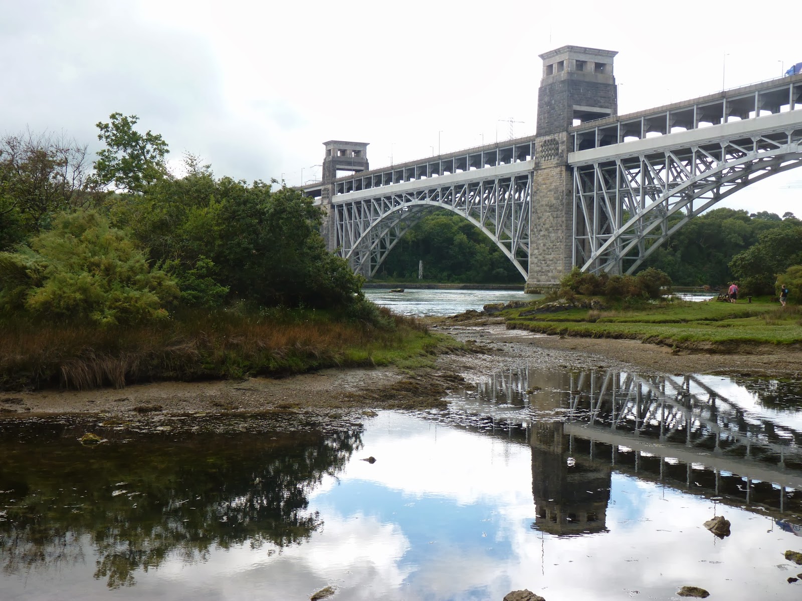


 I suppose I thought of Church Island as the true start of my walk rather than the bus stop at the end of the Bridge or the car park behind Waitrose and it was great to see it again - it is really a rather special place and I was delighted to explore in a little more detail this time. The church itself was open - its interior is a simple one, not as austere as the other Church Island outside Aberffraw but still without frills. I liked it like that, not being a great lover of over-decoration. I hadn’t expected so many churches so close to the coast - two Church Islands, a ruin on Llanddwyn Island, Llanbadrig separated from the sea by the width of a narrow path and of course the church of Church Bay. They’ll be one of the first things I think about when remembering The Path; and the second is perhaps even more surprising - I have loved seeing the butterflies. Peacocks. Tortoiseshells, common blues, speckled woods, meadow browns, orange tips, green-veined whites - they’ve been brilliant and something I never expected to be such a prominent part of the journey.